
The Leverhulme residency at Newcastle University is progressing well. At the moment, I'm working with Dr Alison Williams in the the School of Geography, Politics and Sociology on a short film which fuses B&W aerial footage (shot on a commercial flight to Norway) with cartographic representations of militarised airspace. It's all looking a bit Wings of Desire lite at the moment though (no bad thing, I suppose...).
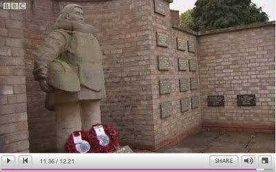
Black Hawk Down in Cley, Norfolk
The crash of an American military Pave Hawk on the north Norfolk coast killing four service personnel is a tragic reminder that the airspace of the UK is regularly used for USAF training exercises.
http://www.bbc.co.uk/news/uk-england-norfolk-25649464
http://www.bbc.co.uk/news/uk-england-norfolk-25649464
Leverhulme Artist in Residence
As of October, I'll be the Leverhulme Artist in Residence in the School of Geography, Politics and Sociology at Newcastle University... excellent news, long commute. I'm aiming to make some work on militarised airspaces in the UK, and collaborating with some excellent critical geographers in the Military, War and Security Research Group at the University. Thank you Leverhulme!
Build Your Own Radar
In the spirit of advanced DIY and my own ongoing, very speculative interest in synthetic vision, I'm posting a talk by Michael Scarito from the DEFCON 19 hacking conference in Las Vegas in 2011. I may just do it...
"Airquakes"
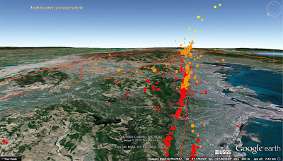
What is an "airquake?" Earthquakes along the Hayward Fault occur at varying depths. Since we cannot crack open Google Earth to show you earthquakes at the depth which they occur, we have color coded them according to their depth. This Google Earth file contains "airquakes"(earthquakes that we have pulled up out of the ground) along the Hayward Fault to help illustrate the orientation of the fault plane below the surface. The yellow coloured earthquakes are 0-3 km deep, the orange colored earthquakes are 3-6 km deep, and the red colored earthquakes are 6-10 km deep.
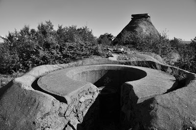
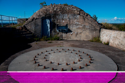
Mineral Defences #1
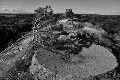
Over summer, I spent some time photographing a demilitarised area on the island of Tjøme near Tønsberg, Norway. Until it was decommissioned in 1999, Torås Fort was a discrete complex of naval artillery emplacements, lookouts, barrack huts, parade grounds and associated infrastructure built (but not completed) during 1939 in anticipation of an invasion by the Nazis. Between 1940-42 the Nazi's then modified and refortified the site for their own purposes. The complex was maintained during the Cold War principally as a training site but the four 15cm Bofors naval cannons remained in place guarding the mouth of the Oslofjord.
The rolling granite promontories and deep wooded undulations are perfect for hiding defensive positions, but having been to Tjøme a number of times in previous years, and being unnaturally drawn to evidence of conflict, I quickly clocked the manmade blisters and hideouts hidden in the dramatic topography of the landscape. Despite being decommissioned, Torås remained closed to the public and effectively remained militarised – that is, until a couple of years ago when the complex was deemed superfluous to defence needs and the military abruptly pulled out throwing the gates open to a curious island community.
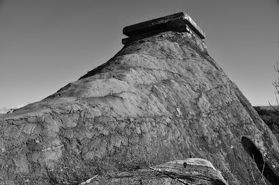
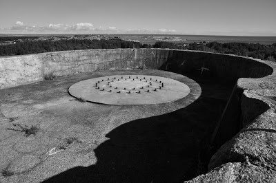
Torås has a number of distinctive features including the cannon emplacements themselves (only one gun remains), ammunitions storage bunkers dug deep into the granite rock, and numerous rock and poured concrete shelters – but none more distinctive than the hilltop command centre. Arguably the highest point on the island, the command centre is effective a man-made hill built using what must have been hundred of tons of rubble and poured concrete to elevate the position above all others in the region. At the summit is a square flat-roofed observation point with narrow viewing apertures which allows 360 degree visibility.
This construction typifies the almost mystical paradox at the heart of much military engineering of this kind: the desire for omniscience (or in modern military parlance, 'total situational awareness') is totally undermined in the battlefield by being the most visible thing for miles around – effectively, a sitting duck. This brings me to the conclusion that the principle function of the command centre is aesthetic, designed specifically for its visual appearance in order to exercise a form of tacit control over the region – a twentieth century Motte and Bailey castle.
Cinematic Geographies
From early September, I will be working as Research Associate (0.5) on a project called Cinematic Geographies of Battersea: Urban Interface and Site-Specific Knowledge. The project is jointly led by Prof François Penz (Principal Investigator), Department of Architecture, University of Cambridge, and Dr Richard Koeck (Co-Investigator), School of Architecture, University of Liverpool. It also includes partners from English Heritage and the University of Edinburgh. I'm very excited about this and aim to post updates of the project on this blog as it progresses.
Defence Image Glitch
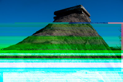
After a couple very tense minutes, Bridge managed to unscramble the images but it gave me enough time to get these screen shots for their novelty value.
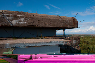
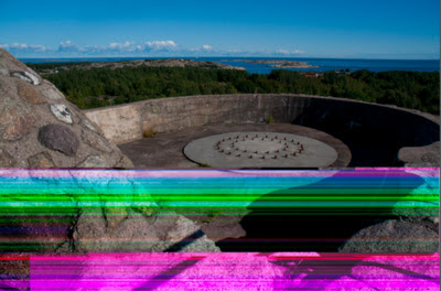
The irony here is that in attempting to remove the colour and concentrate on the formal aspects of the Second World War architecture and the very specific qualities of the local geology, I was blasted by psychedelic colour.
The Military Pastoral Complex
Here is a link to my latest paper, The Military Pastoral Complex: Contemporary Representation of Militarism in the Landscape, at Tate Papers:
Military Globalisation
Tarak Berkawi’s excellent short piece for Aljazeera reminds us that Military Globalisation is Nothing New. It outlines the historical principle that colonial and imperialist ambition projects military might abroad, circulating soldiers from place to place or training indigenous militias to suppress popular uprisings. The piece also shows the seldom connected back story to those positive narratives of global free trade and economic liberalism, a world in which the military act as the ‘steel frame of globalisation’. Much of this may seem obvious, but it is refreshing to read something that doesn’t root military activity simply to territory or ‘national defence’ but exposes the trans-national complexity of current military activity.
Dialogues in Design (poster by Jessica Jenkins). Forthcoming presentation at the RCA (tomorrow, 8th March, 4.30 - 6pm).

I'm doing a 20 minute slot on airspace design.
Blogger Stumbles into Assange Media Scrum
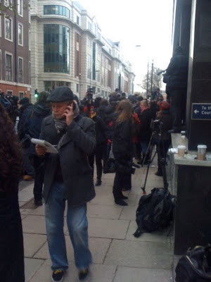
By chance, I found myself in the middle of the international press scrum surrounding the first court appearance of Julian Assange at the Westminster Magistrates' Court today. I'm not sure what this has to do with the project described in this blog, but the incident occurred after spending a lot of time in Westminster observing the general increase in police activities.

See below for details of the theatrical release of Robinson in Ruins, Patrick Keiller’s much anticipated follow-up to London and Robinson in Space.
BFI Southbank – NFT1 - 17.20 – 20 November 2010 – film & panel discussion
Patrick Keiller’s film Robinson in Ruins, released on 19 November, is one of several outcomes of a three-year, AHRC-funded research collaboration between Keiller, Doreen Massey, Patrick Wright and Matthew Flintham.
Following a screening of the film, the co-researchers will present their project as a political intervention. Through its study of a landscape, the project challenges commonly-held assumptions about the current economic and ecological crises: about market forces, commodification, and the terms of belonging in an age supposedly characterised by mobility and displacement.
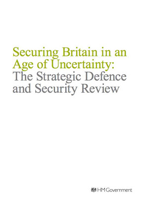
In summary, the SDSR outlines 8% cuts to the British defence budget with
the Royal Navy reduced by around 5,000 personnel, the British Army by 7,000, the RAF by around 5,000 and civilians reduced by around 25,000. Even the Telegraph admits that the MoD got off lightly in this months round of public sector cuts. RAF Kinloss in Scotland will close and Tornado fighters at Lossiemouth will transfer to the UK in a somewhat half-hearted bid to centralise and consolidate the strategic distribution of airbases around the UK. Other RAF bases may be 'repurposed' for use by the other armed services, and the massive MoD training site proposed for St Athan, Wales, is on permanent hold. All of which means that there will be very little difference to the overall size of the defence estate
DDR-Luftraum mit Google Earth
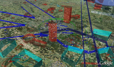
A friend passed me a link to another Google Earth project. This one represents the airspace of the German DDR during the 1980s. It’s very difficult to interpret but it suggests that the divided geographical and social mess of that period also extended into the airspace. Berlin is represented as a confusion of restricted Soviet airspace blocks, Allied zones, military zones, transit corridors, invisible ‘walls’ and other unidentifiable volumes. It is surprising to think that at some level the Allied and Soviet authorities must have had a detailed and ongoing dialogue about airspace design. This project is by the Military Airfield Directory and is definitely a fascinating contribution to the emerging field of airspace ‘histories’.
'For those interested in bombs'
I couldn't embed this BBC video but here's a link to the Newsnight clip. Reporter Mark Urban visits the The IEDD Felix Centre at DM Kineton, Warwickshire. The clip is called 'Learning to be a bomb disposal operator'.
In the Firing Line.
IVSA conference, Carlisle
'The production of micro-time'.

Returned recently from the International Visual Sociology Association conference at the University of Cumbria, Carlisle. I was on a panel focusing on military landscapes led by Rachel Woodward and Neil Jenkins from Newcastle University. Other panelist included Ed Walley (Leeds Metropolitan University) and Gair Dunlop (University of Dundee). Both gave fine papers: Ed focused on the visibility/invisibility of the military presence in Yorkshire with an emphasis on the Cold War, while Gair's paper, Regimes of Time and the Militarised 20th Century, explored what he called the 'production of micro-time' (issues relating to nuclear detonation) through to the 'extended' time of obsolescence and entropy. Gair also produced this astounding image from Operation Tumbler-Snapper. I nearly fell off my chair. It still gives me the shivers today. I subsequently learned that the image, of a 'rope trick fireball' was taken one millisecond after detonation.
‘Dare to dream...'
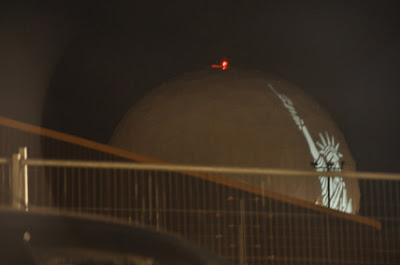
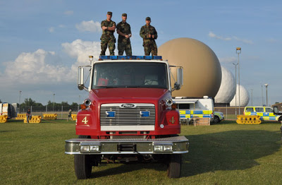
The 4th of July celebrations kicked off at RAF Feltwell with a rousing speech by the director of ‘Tops in Blue’ USAF performance troop, in which we were encouraged to ‘dare to dream’ - about what, however, wasn’t all that clear. It seemed less about the possibility of a change in American foreign policy and more about shoring up those ‘values’ which are apparently so crucial to life in a democratic society. Anyway, this all took place in one of the remaining American military enclaves in East Anglia. Lakenheath and Mildenhall are close by but are possibly too sensitive to host an event which is open to local civilians or interested party crashers like yours truly. Feltwell, it seems is no longer the home of the 5th Space Surveillance Squadron (departed in 2003) which, according to Global Security was ‘responsible for detecting, tracking and identifying the status of satellites orbiting Earth’ using ‘the Deep Space Tracking System (DSTS) and low altitude satellites using the Low Altitude Space Surveillance (LASS) system’. That would account for the unavoidable presence of four unique radomes, one of which was used as an improvised projection screen for a vast image of the Statue of Liberty. The 48th Fighter Wing, our host, (also known as the Statue of Liberty Wing) is also based at RAF Lakenheath where, two days earlier, Joe Biden flew in on a ‘unspecified mission’. I didn’t see him here, anyway…